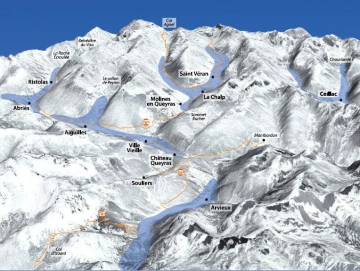
The panorama of Queyras villages
Sotto, l'immagine rappresenta un panorama dei diversi villaggi del Queyras: Abriès, Aiguilles, Arvieux, Ceillac, Château-Ville-Vieille, Molines, Ristolas e Saint-Véran.
From its source on Mount Viso, the Guil begins its swirling descent towards Guillestre and the Durance. It passes through the villages of Ristolas, Abriès, Aiguilles-en-Queyras and Château-Ville-Vieille before entering the Combe at the foot of Montbardon.
At Abriès, it receives the waters of the Bouchet on its right bank, and at Aiguilles, on its left bank, those of the Peynin. At Ville-Vieile, it joins the Aygues, the Aygue Blanche, which flows down from Saint Véran, Europe's highest commune, where roosters are said to peck at the stars, and the Aygues Agnel, which rises on the Col Agnel and bathes Molines on its way down. Continuing its course, it receives on the right bank its tributary which descends fromArvieux, having originated at the Col d'Izoard. Its confluence with the Cristillan, a torrent flowing down from Ceillac, is much later, as if the Guil, tired after its tumultuous crossing of the Combe du Queyras, received reinforcement from the Cristillan before attacking the gorges as far as Guillestre.
As is often the case, geography is the key to understanding history. The Cristillan valley lies outside the Haut Guil basin, so Ceillac remained outside the Queyras until recently. And if you remember that the Guil road was only built in 1855, you'll understand why the Queyras remained isolated for so long.
The average altitude of the Queyras is close to 2,000 m, and more than half of its 2,000 inhabitants live at altitudes above 1,600 m. For a bird's-eye view of the Queyras, there's no better way than to climb to the top of the Sommet-Bucher (2254 m). The 360° panorama takes in the entire Guil basin and the farthest peaks of the Alps.
The image below shows a panorama of the various Queyras villages: Abriès, Aiguilles, Arvieux, Ceillac, Château-Ville-Vieille, Molines, Ristolas and Saint-Véran.

From its source at Mount Viso, the Guil begins its swirling descent towards Guillestre and the Durance. It passes through the villages of Ristolas, Abriès, Aiguilles-en-Queyras and Château-Ville-Vieille before entering the Combe at the foot of Montbardon.
At Abriès, it receives the waters of the Bouchet on its right bank, and at Aiguilles, on its left bank, those of the Peynin. At Ville-Vieile, it joins the Aygues, the Aygue Blanche, which flows down from Saint Véran, Europe's highest commune, where roosters are said to peck at the stars, and the Aygues Agnel, which rises on the Col Agnel and bathes Molines on its way down. Continuing its course, it receives on the right bank its tributary which descends fromArvieux, having originated at the Col d'Izoard. Its confluence with the Cristillan, a torrent flowing down from Ceillac, is much later, as if the Guil, tired after its tumultuous crossing of the Combe du Queyras, received reinforcement from the Cristillan before attacking the gorges as far as Guillestre.
As is often the case, geography is the key to understanding history. The Cristillan valley is far from the Haut Guil basin, so Ceillac remained outside the Queyras until recently. And if you remember that the Guil road was only built in 1855, you'll understand why the Queyras remained isolated for so long.
The average altitude of the Queyras is close to 2,000 m, and more than half of its 2,000 inhabitants live at altitudes above 1,600 m. For a bird's-eye view of the Queyras, there's no better way than to climb to the top of the Sommet-Bucher (2254 m). The 360° panorama takes in the entire Guil basin and the farthest peaks of the Alps.